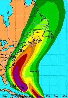
As of now Earl is expected to brush the Outer Banks before moving off to the North Northeast which would take the center a couple of hundred miles off the coast here. The National Hurricane Centers threat map shows that the seaside here has a moderate threat of tropical storm winds when Earl passes. The bayside is showing a low threat as of now. Again, a minor drift to the West would dramatically affect the weather here and what we receive.

Shore residents should monitor Earls progress and be prepared to act if conditions change. As of now no evacuations are contemplated. The main effect of Earl on our weather should be rough surf and strong rip currents. There could be some minor flooding with winds expected to be between 30 and 40 mph, from the northeast late Thursday or early Friday morning. The worst of the winds will occur at the seaside beaches and away from the coast winds should be in the 20 to 30 mph range.
Earl is moving north northwest at 16 mph and should increase in forward speed as it moves north. Thats good news because the worst of the weather here will be relatively brief. However you should avoid going to the barrier islands through the weekend because those strong rip currents and heavy surf will be very dangerous.
Still you should have plans in place to act quickly if necessary. This is the height of the hurricane
 season and there are other areas of concern moving off Africa which could move our way. Shoredailynews.com has a brand new hurricane preparedness section which contains extensive information including shelter options and flood zone maps for both counties, and tips on what to do before, during and after the storm.
Pictured top: The likelihood of areas experiencing hurricane force winds.
Pictured below: The likelihood of areas experiencing tropical storm force winds.
Charts courtesy of the National Oceanic and Atmospheric Administration.
www.shoredailynews.com
No comments:
Post a Comment